Popular Posts

Monday, August 30, 2010

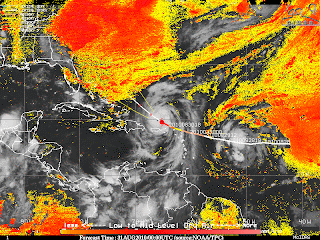
Will Hurricane Earl strike Eastern USA?

above- THE COMPUTER WEATHER MODELS OF CIMSS OF 00Z,31ST AUG 2010 ARE INDICATING THE TARGETED PATH OF EARL. THE YELLOW-ORANGE PATCH EAST OF US IN ATLANTIC IS INDICATING THE PRESENCE OF DRY AIR WHICH MEANS DRY AIR FEEDS IN THE SYSTEM OF HURRICANE AND WEAKENS IT.


METD WEATHER,
Akshay Deoras,
Severe Weather Forecaster

Hurricane Earl has gained up speed and symmetry and has reached the Cat.4 Hurricane mark in the North Atlantic ocean.Already affecting the US Virgin Islands and Puerto Rico, Earl now has an almost clear strengthning passage in the North Atlantic as it surges towards US Eastern Coast

The Forecast models of 00z,31st AUG are clearly indicating that no significant wind shear is expected to build in Earl's forecasted path. However, there seems to be a formation of a 30-40kt wind shear just in the latitude of Florida tip in Atlantic and presence of some dry air on the way
It means that Earl initially Earl will intensify more in next 36hrs till some Mid level wind shears form and affect the symmetrical figure of the Major Hurricane.
Also being shown by the models, a lot of dry air is likely to be present on Earl's forecasted path after 36hrs i.e at 24.6N,71.4E co-ordinates
This all will result in the gradual weakening of earl as it approaches CAROLINAS COAST

Will EARL STRIKE USA??
This seems to be a Billionaires question!
Right now, it looks like almost all the weather models are saying that Earl will miss from making a landfall at Carolinas coast. The steering winds from USA is likely to keep Earl shifting eastwards on the track and some strong winds can make earl to miss US.
But, I am still believing that Earl will definately make a partial landfall just East of Jacksonville in Georgia state
The entire coastal east is going to be affected by heavy rains and strong winds on Thursday evening due to Earl

Heavy rains hits Nagpur on Sunday evening and Monday


ABOVE IS THE WATER LOGGING IN OUR AREA NEAR MY HOUSE IN NAGPUR
IN THE SECOND IMAGE, MY LEGS ARE SUBMERGED UNDER THE WATER

METD WEATHER,
Akshay Deoras,
Severe Weather Forecaster

Current weather @ 1400hrs,30th Aug-- EXTREMELY HEAVY RAINS IN NAGPUR WITH POOR VISIBILITY AND FLOODING POTENTIALS

As was expected, Sunday proved to be a massive rainfall day though it couldn't set a record. As soon as heavy rains hit the city, water logging problems were reported and even my legs were submerged in water at Civil Lines, area

On sunday, an expected multi-vortex system stretching from Gujarat to East Maharashtra caused some heavy rains in Northern Maharashtra.
Rains began by 4PM and ended by 6PM. Amount of rainfall recorded at the METD HQ. was about 48mm on Sunday

On Monday, a low pressure system was expected to form and has formed just North of Nagpur as a result the air pressure recorded at Nagpur is 999mb and has a FALLING tendency.
Very heavy rains will continue throughout the day with patches of very heavy and calm rainfall

flooding potentials also exist in low lying areas near the city.
Tuesday the rainfall is expected to decrease and AGAIN INCREASE ON 3Rd SEPTEMBER 2010 IF THE WEATHER MODELS GO TRUE.

I will have a post on Mumbai and Gujarat rainfall in these two days by late night or late evening

Saturday, August 28, 2010

Heavy rains likely in Maharashtra in the early upcoming week

METD WEATHER,
Akshay Deoras
Severe Weather Forecaster

After more than a week of absence in my passionate field due to some other important work ongoing, I finally managed to get some time for the weather forecast of the upcoming week in India

Right now, a bimodal system of low pressures has formed over India due to rapid strengthening of the low 850mb air pressures. One of this system which is set up over SE of Rajasthan as per the 12z UTC pressure map of Thai Meteorological Dept. The origin of this low pressure happened a few days back from the coasts near Tamil Nadu. This system was responsible of bringing very heavy downpours over Nagpur at dawn period

This low pressure is not expected to maintain the intensity in the next 12-24hrs as a result of the weakening its likely going to cause very very heavy rains over Western India esp Mumbai and nearby areas and some rains at the Southern Tip of Gujarat
Meanwhile, the rainfall is likely to be intensified due to the formation of a Mid-low level Vortex system. So heavy rains initiating Sunday Evening to night hours will hit entire Northern Maharashtra including Mumbai and vicinity.
On Monday also very heavy rains will hit Mumbai city and the mentioned places due to the vortex system under the influence of a weak low pressure!
The second system which is centered over Bihar is likely to progress south wards and sweep across central states intensifying and causing rains on the way

So the Northern Maharashtra will get heavy rains due to this low pressure

Nagpur-
Rainfall will continue on Sunday very early morning time. Its expected to be heavy with thunderstorm
Sunday night- Rains will be moderate and initiating at late night period

Thursday, August 26, 2010

Gulf Stream Update


I would like to state that the gulf stream has improved slightly over recent days, however I use the word improved very cautiously.   There is still a clear breakage in the loop current and a lot of factors including sea temperature suggest that the UK and Northern Europe are in for a dire winter as previously outlined in my previous posts to date.  After a lengthy discussion this morning with another colleague, I feel it is also important to mention the Milankovitch Cycle and where we are today with it, which appears to correlate very well with ice ages/cooling.

http://www.iccfglobal.org/ppt/Illarionov-01-10-04.ppt

Friday, August 20, 2010

Unexpected rainfall around Nagpur and some parts of Maharashtra

METD WEATHER
Akshay Deoras,
Severe Earth and Space Weather Forecaster

The low level moisture patterns in Vidarbha already has started fading away indicating the monsoon has become weak over the Eastern Maharashtra though vigorous yesterday,thursday around Yavatmal district! The temperatures have started increasing along with the moisture laden air increasing the heat index upto 40C making uncomfortable periods inside houses

Overnight, an unexpected system developed around the eastern maharashtra and caused some solid rainfall during the day hours in some areas of Nagpur. Rainfall estimate from 0000hrs-12:46PM on 20th August at the headquarters near to 20mm rains which was not forecasted by any weather model
The GFS meteograms were indicating some chance of rains but the quantum is uncertain almost everyday since there is a lot of fluctuations in the moisture vs accumulated precipitation models

Since this system has moved well off towards Mumbai and the conditions are now opening in Nagpur, this can perhaps provide some warmth for another approaching system which can again pour some rains late afternoon.Going with the GFS, I dont find any rains in the afternoon period
Also SOME HAVE CLAIMED THAT THE HEAVIEST RAINS OF THIS SEASON HAPPENED IN DELHI ON THURSDAY
Due to some very personal work in the approaching week, I will not be able to make any weather forecast till 27th August 2010. The weather forecast for other areas also will be offline!

Wednesday, August 18, 2010

MASSIVE CORONAL MASS EJECTION IS EJECTING FROM SUN! MIGHT HEAD TO EARTH


IMAGES-
THE FIRST IMAGE IS OF THE LASCO C2. IT IS A CORONAGRAPH OF THE SUN TAKEN AT 0636. THE BRIGHT CORONAL MASS EJECTION CAN BE EASILY SEEN ON THE RIGHT PART OF THE SUN

2ND IMAGE IS A 6MIN EARLY IMAGE THAN THE FIRST ONE AND A LONG RANGE CORONAGRAPH
THE BRIGHT EXPLOSION IS THE CME!!

THIRD IMAGE -
THE 0658UT IMAGE OF SUN IN THE FE XVIII 94 ANGSTROM REGION OF SUN
YOU CAN SEE THE EXPLOSION ON THE UPPER RIGHT PART OF THE SUN

FOURTH IMAGE IS OF THE MAGNETOGRAM FROM SOHO
IT SHOWS OPP. POLES IN THE SUNSPOT 1098


Massive Cornonal Mass Ejection also designated as CME is now exploding from the sun associated with a CLass C4 flare!

At about 0600UT, The SDO X ray flux recorded a Class C4 solar flare ejected from the sun and then immediately datas from the coronagraph of SOHO confirmed that Sun is hurling MASSIVE CME which triggered after the solar flare! The SOHO MDI Magnetogram has been indicating that the opposite poles are present in the Sunspot 1098. So the magnetic fields around 1098 became repulsive(weak) and ejected a solar flare.
Soon after the flare, Coronal Mass Ejection was ejected.
I don't find any coming Solar Radiation storm as after the ejection, the proton flux plot remained quiet unlike the previous time when a C4 caused a solar radiation storm on 14th August 2010
I have less information on the present side of earth as viewed from the sun but strongly believe that this CME is ejected towards the earth and mostly some part of it can likely give a glancing blew to earth's magnetic field by 21st August 2010

meanwhile, the previous estimates didn't materialize and the disturbance in the geomagnetic field of the earth remained less.

Saturday, August 14, 2010

Low Pressure over Central India bringing some rains after a week gap


METD WEATHER
Akshay Deoras
Severe Space and Earth Forecaster

With a week lul SW monsoon over central just due to absence of a strong low pressure, a weekly low formation system from the bay created another the low pressure which now rests NE of Central India. This low has pulled sufficiently moisture from the Arabian Sea to trigger rains over Central India. For Nagpur, the daytime heat pulled away the moisture and as night arrived, an increase in the low level moisture creating a very saturated atmosphere triggering rains in Nagpur
The Rainrate will be on a rise over night as more saturation and condensation happens!
Some heavy rains are likely till sunday mid day over Western MP and eastern Maharashtra

I expect some quiet weather from the next week as another low not expected to form

Gulf Stream situation has got worse!

Sorry guys, a lot of people have tried to debunk the whole gulf stream situation over the past few weeks, unfortunately the situation has actually worsened.  Scientists did not appear concerned as there was still apparently some strength in the gulf stream current.  This is denoted by the red colours in the previous data screens, however todays screen shot below shows a different story altogether.

Much more disturbing than the last data shots, as you can see the gulf stream has established a route within the gulf of mexico as I suggested in my last post, the red colours denote the sea surface velocity, ie the strength of the current seems to be in one position that no longer feeds towards the UK or Northern Europe.

Couple this with other current events such as the unusual behaviour of the sun and it's minimal sunspot activity, which I also reported in my last post as well as the situation with the current la nina (ocean cooling), you can actually find that all the cold cards for three major factors on our climate are in play for this coming Winter! like I stated the effects of the gulf stream will be bad enough if nothing changes!!! and it has worsened, my seasonal forecast for winter 2010/2011 would therefore have to change to SEVERE SEVERE COLD for the UK and Northern Europe which could resemble little ice age conditions or worse over the next few years.

We also need to consider the effects of the icelandic volcano on the UK, many volcanoes in the past have had serious effects on our climate for many years to follow, the debris enters the atmosphere and takes years and years to clear, blocking out any sunlight and resulting in drastic cooling.  So that's now four cold cards in play for this winter.  Surely not, yes brace yourselves there is another; a recent report from CNN news explains how scientists are baffled by the shrinking of the upper atmosphere.
http://edition.cnn.com/2010/US/07/16/nasa.upper.atmosphere.shrinking/index.html?hpt=Sbin#fbid=yWryq8qJXrv&wom=true

Well all you baffeld scientists its very simple really, the sun is the major driver of our climate system, sunspot activity is at an all time unusually low period, this effects everything and in return cools our planet.  So that is now five major cold cards in play, this is no coincidence, it's all part of the earth's natural cycle sytems that relate and correlate with sunspot activity.

The effects are much more than just cooling on the UK and Northern Europe, even when the gulf stream just alters slightly it can change rainfall patterns all over the world, I suggest this is what we are seeing in Pakistan and Colombia at the minute, it really is annoying when I now see news reports picking up on major events in short succession and blaming it on the jet streams, the gulf stream operates on trade winds of course this will effect the jet streams, but they are not going to tell you on the news that the gulf stream has stopped/been interupted, they all know that most people have seen the film the day after tomorrow.

Start preparing for Winter 2010/11 now!  the effects on the floods in Pakistan and Colombia have been fairly rapid in response to my past posts on the whole situation, this will not pass us by!

Thursday, August 12, 2010

SLIGHT RISK in upper USA on Friday

METD WEATHER,
Akshay Deoras
Severe Space and Earth weather Forecaster,

Severe Thunderstorms are expected to develop to the east of the persistent 70kt upper level jets. With a nice warm,moist sector extending in most of Iowa,WI,MN, Severe thunderstorms will develop in the strong CAPE and in the presence of the Low pressure in the north and good LLJ pulling moisture reaching dewpoints near to 75F!
Convection will be inhibited till Friday afternoon due to a strong CAP which will break just in the afternoon when the warm front sweeps across IOWA and tripple point arrives in Minnesota.
A nice low level shear is also present in the cold front and near the tripple point.
Organized storms are possible with some isolated thunderstorms also converting to supercells
The risk for DAMAGING hAILS and winds is more than tornado.However given the nice kinematics, tornadoes are possible in the Slight risk area

The setup looks like a bimodal system. One affecting IOWA then surging towards OHIO and the other developing in the tripple point area around the WI and MN border and surging towards canada
I will go with the IOWA system and place my tornado target near SE IA.


Tuesday, August 10, 2010

LEH DEATH TOLL INCREASES AGAIN!

The toll of the dead at leh has now risen to 166 with 400 missing
23 foreigners lost their lives in the flash flood
Three french,one Italian and person from Spandrid were killed

Three French citizens — Augavelis Henri, Hellot Jacques and Daniel Hauri, an Italian identified as Riccardo Titton and Maromas Maria Lousdes from Spain have been declared dead, they said.

Sixteen of those killed are from Nepal, namely Nema Zangmo, Tsering Neklal, Bakta Bahadur, Kama Lama, Ajay Raina, Khunchok Gelak, Lakpa Gyalmo, Shekhar, Mahurdin Ansari, Manee Patel, Ramesh Patel, Narai Badur Sume, Santosh Kumar, Nel Badur, Saryanareyan Chaudhary and Anil Chaudhary, they said.

Two other victims were Tibetans. They were identified as Pasang Tsering and Tsering Yangkyid, the sources said.

LEH-SRINAGAR ROAD-- CLOSED

LEH-MANALI ROAD -- CLOSED

The flight operations are on a full swing

The list of those who have died is put on-

leh.nic.in


Sunday, August 8, 2010

GUJARAT FLOODS DUE TO HEAVY RAINS. DEATH TOLL RISES IN LEH

As was expected, the low pressure is bringing some very heavy rains in Gujarat especially Vadodara and Ahmedabad.
Four persons were killed in Ahmedabad due to a house collapse.10 inch rainfall has been reported in last 12hrs. Heavy rains are very likely on Sunday and Monday. PLEASE KEEP CHECKING THE ALERTS ON METD WEATHER ON FACEBOOK,TWITTER AND BLOG

VIDARBHA-
There is some relief from rains on Sunday as was expected but still many areas in foods. Chandrapur district villages are facing floods and also some areas in the Central Maharashtra and Vidarbha

Rainfall will be on a decrease in Vidarbha from Sunday itself

LEH
The Death toll is rising in Leh and now about 145 people have been reported to have died due to the flash floods. Still 500 people are missing. There is almost no count of the injured and affected
The air transport has been reviewed for commercial flights also
As a result, Flights of Air India, Jet airways and Kingfisher could make it to Leh and transport people safely from Leh to Delhi
People who have E-Tickets are facing problems in Leh as due to lack of networks of airlines, the ground staff is unable to retrieve their tickets.
As a spoke to my friend from Gujarat, he informed some of his friends landed safely due to military help in military aircrafts
Rescue work is still in full swing and the weather permitting. I see some patch of rains in Leh on Wednesday and Thursday. I will notify later.

Road status-
SRINAGAR-LEH -- CLOSED(CLOSED FROM NAMIKALA TOP)
MANALI LEH- -- CLOSED
The roads continue to remain close due to landslides. Aproximately 5 bridges on Leh-Kargil route have been broken with a fresh break possible in Bor Kharbu which is apx 3hrs from Leh just before Lamayuru.
Leh Manali road is expected to open in 2-3 days as BRO is engrossed in clearing road!

LEH'S DRUK WHITE LOTUS SCHOOL DESTROYED
The DRUK WHITE LOTUS SCHOOL which is at Shey in Leh has been totally destroyed and mud over 2-3 ft is at the campus. This school was featured in the Megafilm of Bollywood-" 3 Idiots"
See video here

COURTESY- STAR NEWS, INDIA
Still many villages are out of help.
METD WEATHER AND AKSHAY'S GYAAN BLOG HAVE BEEN POSTING AND WILL POST UPDATES FROM LEH. THE 24HRS EMERGENCY NUMBER IS ALREADY ON OUR BLOGS

Saturday, August 7, 2010

Rain havoc in Central India

ABOVE- THE CONCENTRIC CIRCLES REFER TO SURFACE LOW AT 850MB MAP
AS ALERTED BEFORE, PEOPLE LIVING IN LOW LYING AREAS ESP. RIVERSIDE OF BHANDARA AND GONDIA DIST WITH WARDHA DIST ALSO SHOULD MOVE TO SAFER PLACES

** HEAVY RAINS RESERVED FOR GUJARAT ON SUNDAY AND MONDAY

METD WEATHER,
Akshay Deoras,
Severe Weather Forecaster

With the surface low pressure of 996mb as being designated by the GFS Thai maps centering over Central India, Heavy rains created a havoc in the part on Friday and Saturday.
The quantum of rains are-
The datas of rains on Friday till Saturday morning-
Parbhani-170mm,Mahur-140mm,Nanded-110mm,Nagpur-52mm

Nagpur recorded 66mm rainfall on Saturday AND 5-6 DEG CELCIUS TEMP DROP IN MANY AREAS

Problems due to the rainfall-

NAGPUR AIRPORT CLOSURE DUE TO LOW VISIBILITY
Due to overnight rains in Nagpur after solid spells on Friday, fog mostly was created in Nagpur
The visibility of Nagpur Runway was dropped on Saturday morning and the airport was declared closed
JUST ONE FLIGHT OF GO AIR FROM DELHI TO NAGPUR C'D MAKE IT TO THE AIRPORT WHILE THE REST MORNING FLIGHTS WERE DIVERTED TO HYDERABAD, BHOPAL,MUMBAI. THE GO AIR FLIGHT ALSO CIRCLED OVER NAGPUR BUT DUE TO DENSE CLOUD COVER IT HAD TO RETURN TO BHOPAL. THE PILOT TOOK THE RISK TO LAND AND MADE THE AIRCRAFT LAND AT NAGPUR. THIS WAS TOLD BY MY UNCLE WHO TRAVELED ON THIS FLIGHT.
In Evening and night, Rains continued in Nagpur and just one flight to Mumbai took off and the rest were cancelled...

POTENTIAL FLOODING
Some flood situations are being reported in many areas in Vidarbha,Marathwada and the other affected districts.The Wainganga river is flowing above danger level after the gates of Irai dam were opened followed by heavy rains in Chandrapur.
12 gates at Irai dam were opened
**2] Water overflow was reported near the railway bridge in Pulgaon near Wardha affecting railway traffic
**3] The gates of Sanjay Sarover damn were opened in Seoni
**4] Rivers in Bhandara and Gondia districts are likely to overflow due to it

DISRUPTION ON ROAD TRAFFIC
Tuljapur-Nagpur highway was closed due to severe rains

WATER LOGGING
Water logging problems have been reported in many areas!

METD WEATHER PRE FORECAST OF THIS INCIDENT
ON FRIDAY,6TH AUGUST 2010 EARLY MORNING METD WEATHER HAD ISSUED A PDS AND MARK 5 ALERT FOR CENTRAL INDIA AND I HAD MENTIONED THAT FLOODING SITUATIONS ARE LIKELY.THE EXACT SCENARIO HAPPENED. THUS ACCURACY EXIST!

METD WEATHER FORECAST
All this was due to a low pressure which had set over Central India and had intensified on the way. I am able to see the additional moisture due to this system over Central India
On SUNDAY, rainfall will still hammer parts of Eastern and Central Maharashtra and will add more to the problems BUT IN LESS SCALE as I am seeing the low pressure to move over Gujarat.
Nagpur- Rains will continue on Sunday also. In all will be a rainy day and a COOL DAY

RAIN QUANTUM WILL DECREASE FROM MONDAY...


UPDATE FROM LEH AND THE EMERGENCY NUMBER

Anyone wanting to enquire about the status of the injured or dead can contact on following numbers- 9906990613, 9906990833, 9906990807, 9906983544, 9906990748, 9906990835 and 9906990787.
With 48hrs passed from Leh incident, things have not changed at all despite military and local people are doing their best. The toll of dead is increasing everyday and now it is 130!
LEH'S Kushok Bakula Rimponchee airport's runway has been restored today. The Indian Air force operated two llyushin-76 aircraft and four antonov 32 aircraft to Leh carrying 125 persons from National Disaster Response Force(NDRF) carrying medicines, X ray machines,tents

The toll of dead is feared to go up and more injuries to see. There are still dozens of villages in Leh where relief hadn't reached and which still are in darkness.
There is simply nothing to write on this matter both in context of matter and my feelings
I am totally off due to bursts of tears when I see LEH photos..

METD WEATHER's information gets on AIR and blog on The Weather Channel in USA

With a day after the tragedy happened in Leh due to the cloudburst killing over 118 people and living 10,000 affected!

There is still suspicion on the amount of rainfall received at Leh during Friday as there are no Indian Meteorological Department's Weather Office to record the data from rain and also on the rain rate which has been the most important

The rain rate as mentioned by an unknown source (possibly by IAF) is 48.26mm or 1.9" rain in 1 minute in Leh. I conveyed this information to USA's The Weather Channel, Dr. Greg Forbes on facebook. Dr Greg, discussed on World's record breaking rain rates and showed some videos of Leh flash flood. As it is still not confirmed, TWC mentioned a question mark infront of Leh 1.9" rain after I reported them

The entire article can be seen here

The recovery work continues in Leh but was slowed down in the morning due to some rains
The IMD is saying that it must have rained about 100mm/hr in leh which also c'd have triggered rains but if one sees the damage and listen the eyewitness interviews, things don't seem so
I still believe that the cloudburst has been a solid one as Leh sees 90mm rain/year and no thing big possible when it rains on a single day in an hour
EYEWITNESS INTERVIEWS
THE EYEWITNESS INFORMED THAT THERE WAS A STRONG WATER WAVE OF 15FT APX OVER LEH JUST AFTER THE CLOUDBURST. AS MENTIONED EARLIER, THE CLOUDBURST HAPPENED AT KHARDUNGLA PASS WHICH IS AT 18300FT AND LEH IS JUST 11000 FT. SO WATER WITH MUD MUST HAVE FALLEN FROM THAT PEAK AND RESULTING IN SUCH CONDITIONS
I AM TRYING TO FIND AN OFFICIAL DATA BUT SEEMS WILL NOT BE POSSIBLE SINCE "BELOVED IMD" HAS SET UP NO RADAR OTHER THAN FEW CITIES

ALSO ON THE WEATHER CHANNEL, A PROG WAS FEATURED LAST NIGHT AFTER METD WEATHER PROVIDED THE INFORMATION

Friday, August 6, 2010

MODERATE TO HEAVY RAINS HEADING TOWARDS WEST COAST OF INDIA

METD WEATHER,
AKSHAY DEORAS
SEVERE WEATHER FORECASTER

With the westward progression of the surface low pressure towards Western Coast of India, Moderate to heavy rains are likely to hit Eastern Gujarat,Southern Gujarat,Daman Diu,Mumbai,Pune,Goa and some interior western maharashtra from Saturday,7th August till 9th August

The amount of rainfall will decrease in Eastern and Central Maharashtra from Saturday

LEH CLOUDBURST IN DETAILS

HOUSES DESTROYED IN LEH
SOURCE- AFP
ITS DIFFICULT FOR ME TO BELIEVE THAT SUCH A MASSIVE CLOUDBURST HAS HAPPENED IN LEH TRIGGERING SEVERE RAINS AND FLASH FLOODS

ACCORDING TO THE LOCALS, THE CLOUDBURST HAPPENED BETWEEN 12-2AM ON FRIDAY AND LASTED FOR A VERY SHORT TIME.

THE TOLL NOW RISES TO 103 AND ATLEAST 370 PEOPLE INJURED AS PER THE STATE POLICE.25 ARMY JAWAN ALSO MISSING
VILLAGES OF PHYANG, CHOGLAMSAR, SABU AND NIMOO ARE THE MOST HIT!
NIMOO IS ABOUT 40KM AWAY FROM LEH
PHYANG IS JUST 10-13KM FROM LEH

LEH AIRPORT HAS BEEN WATER AND MUD LOGGED, LEH NEW AND OLD BUS STAND ARE DESTROYED TOTALLY, ABOUT 200 STUDENTS WERE RESCUED FROM DRUK WHITE LOTUS SCHOOL OR SCHOOL SHOWN IN THE HINDI FILM 3 IDIOTS
THE BSNL LEH OFFICE, CRPF OFFICE, ITBP HEADQUARTER, A POLYTECHNIC COLLEGE IN LEH ALSO AFFECTED.

FAQ-
WHAT ARE CLOUD BURSTS
Cloud bursts are a type of rainfall that happens from high top clouds or cool topped clouds
Mostly it happens from a Cumulonimbus(CB) cloud. Warm, moist air keeps on rising in the clouds thus making an updraft of the clouds as most of the times there is updraft of moist air... This updraft prevents the clouds from causing a downpour as rain or Hails (In the CASE of CB cloud) falls as an downdraft of the cloud or the storm system.
In hilly regions, mountains are a barrier to this updrafts and cause the cloud to release the downdraft suddenly which lasts for a few minutes but causing a precipitation of 100mm in an hour.

Most of the times, there is hail, and thunder with the downdraft along with the rains.
Such cloudburst are most likely to trigger flash floods
THE PREVIOUS RECORDS OF HIGHEST RAIN RATE FROM CLOUDBURST HAS BEEN BROKEN BY THE LEH CLOUDBURST WHICH HAPPENED ON AUGUST 6 2010

Record Cloudbursts

Duration↓Rainfall↓Location↓Date↓
1 minute1.9 inches (48.26 mm)Leh, Jammu Kashmir, India06 August, 2010
1 minute1.5 inches (38.10 mm)Barot, Himachal Pradesh, India26 November, 1970
5 minutes2.43 inches (61.72 mm)Port Bells, Panama29 November, 1911
15 minutes7.8 inches (198.12 mm)Plumb Point, Jamaica12 May, 1916
20 minutes8.1 inches (205.74 mm)Curtea-de-Arges, Romania7 July, 1947
40 minutes9.25 inches (234.95 mm)Guinea, Virginia, USA24 August, 1906

Source- Wikipedia.org for cloudbursts.

WHAT HAPPENED IN LEH ON 6TH AUGUST 2010
A SUDDEN AND SERIES OF CLOUDBURST STRIKED NEAR KHARDUNGLA PASS WHICH IS AT 18300FT ABOVE SEA LEVEL AND 39KMS FROM LEH.
THIS CLOUDBURST TRIGGERED RAINS IN LEH AND NEARBY AREAS AND AS MOST AREAS HAVE MUD HOUSES THEN HOUSES GOT COLLAPSED,

LEH MANALI ROAD ALSO WITNESSED CLOUDBURSTS NEAR ZINZINGBAR AS A RESULT MANY PEOPLE WERE STRANDED NEAR BARALACHA PASS.

ON LEH-SRINAGAR ROAD,
MANY LANDSLIDES AND MUD SLIDES WERE REPORTED ON THE WAY WITH SOME SEVERE NEAR CAPTIAN'S MODE ABT 100KM FROM SRINAGAR

METEOROLOGICAL HISTORY
SOME HEAVY RAIN PATCHES WERE SEEN IN EASTERN JAMMU AND KASHMIR
WITH SOME STRONG CAPE OVER LEH, THE UPDRAFTS W'D HAVE BEEN MASSIVE WITH TALL CLOUDS THOUGH NOTHING HAS BEEN RECORDED BY ME AS I DIDN'T FOCUS ON J&K LAST NIGHT

HEAVY RAINFALL IN CENTRAL INDIA IS GOING TO BE A PROBLEM

METD WEATHER,
AKSHAY DEORAS
SEVERE WEATHER FORECASTER

A MARK 5 ALERT + A PARTICULARLY DANGEROUS SITUATION FOR VIDARBHA AND DISTRICTS ON THE SE LINE OF MAHARASHTRA

THE PERSISTENT LOW PRESSURE IS CAUSING A VERY HEAVY RAINFALL IN NAGPUR AND AROUND AREAS. PEOPLE LIVING IN LOW LYING AREAS ARE REQUESTED TO MOVE TO HIGHER PLACES AND TORRENTIAL FLOODS ARE LIKELY AFTER THE INTENSITY
DISTRICTS FALLING IN THE 200KM RANGE OF NAGPUR ARE ALERTED

FRIDAY- HEAVY RAINFALL WILL END TILL LATE EVENING TO EARLY NIGHT HOURS
THEN MODERATE RAINS WILL CONTINUE TILL MIDNIGHT
RAIN RATE AND QUANTUM WILL DECREASE SINCE SATURDAY EARLY MORNING PERIOD
SATURDAY WILL SEE LESS RAINS

MASSIVE CLOUDBURST STRIKES LEH

A massive cloud burst hit the city of Leh and Choglumser which is 13km around Leh triggering flash floods in LEH causing landslides
TWO CLOUDBURSTS HAPPENED ON THURSDAY MIDNIGHT IN LEH WHICH
TRIGGERED SEVERE RAINFALL OF SHORT TIME ALSO DEFINED AS CLOUDBURST
AS A RESULT OF THAT RAINFALL, THERE ARE LANDSLIDES ON KARGIL-LEH
ROUTE, MANALI LEH ROUTE IS SUBMERGED UNDER WATER NEAR LEH
** LEH CITY AIRPORT HAS BECOME NON FUNCTIONAL DUE TO DEBRIS, WATER
LOGGING OVER THE RUNWAY. RUNWAY WILL BE RESUMED FOR OPERATIONS
TODAY EVENING.
** NEARLY 42 BODIES HAVE BEEN RECOVERED FROM DEBRIS AND OVER 200
PEOPLE INJURED
** SABULA VILLAGE NEAR CHOGLUMSER HAS BEEN THE WORST HIT
** BSNL OFFICE, ITBP HEADQUARTERS, POLYTECHNIC COLLEGE AMONG THE WORST
HIT

** CLOUDBURST IS A SHORT TIME RAINFALL FROM A HIGH TOP CLOUD
OR CUMULONIMBUS CLOUD WHICH TRIGGERS HIGHEST RAIN RATE
IT CAN EASILY CREATE FLOOD SITUATIONS
ON 26TH NOV 1970, IT RAINED 38MM IN 1 MINUTE IN BAROT,HIMACHAL
PRADESH

Wednesday, August 4, 2010

Heavy rains possible in evening on Thursday

Some heavy rains are possible in evening to night hours in Nagpur.
The afternoon will be cool and might have a spell of shower. Around 7PM, it can rain heavily continuing till night!
Stay safe!

--
Akshay Deoras,
akshaydeoras.blogspot.com
metdweather.blogspot.com
P- 94223-13055

Breaking News! The Gulf Stream has Stopped!

There is recent and very strong evidence that the gulf stream has actually stopped! which I have frequently suggested and reported on throughout my work and blogs over the years.  The main loop or the so called engine which generates the majority of the heat for the gulf stream has detached itself.  This is clear to see from the NOAA in the form of RTOFS (Altlantic) graphic nowcasts from over the past three months.

28th April 2010 - as you can see from the bottom left hand corner, the gulf stream appears to be working and sending warm water towards the UK in the top right hand corner.


7th May 2010 - in the bottom left hand corner you will now notice a loop in the main engine of the gulf stream within the gulf of mexico in comparison to the previous data screen.

7th July 2010 - The loop has now detached itself from the gulf stream and is shown as a figure of 8 in the bottom left hand corner of the data screen.

27th July 2010 - the following data is quite disturbing! as you can see the main engine has detached itself from the gulf stream, I have studied the gulf stream intensely over the past several years and never seen anything like this before.

I am still hoping that this is an Eddy (sections of moving water that can swirl off) but if I am to be honest, the high realism is that this is not, eddys do not swirl off in a clockwise direction in the size of an American State and completley detach themselves in this manner, I would even like to make a scientific suggestion here and state that the USA is likely to get warmer from this as the current may establish a new path in the gulf of mexico, where as the United Kingdom and Northern Europe will experience severe cooling. This is identified in the data screen dated 27th July 2010 above, it is clear to see that the gulf stream has stopped and is no longer sending warm water to the UK, compare the top right hand corners of each of the previous data screens to see this for yourself.

Now compare this with other current events such as the unusual behaviour of the sun and it's minimal sunspot activity, which I reported on last month as well as the situation with the current la nina (ocean cooling), you can actually find that all the cold cards for three major factors on our climate are in play for this coming Winter!  the effects of the gulf stream will be bad enough if nothing changes!!!  my seasonal forecast for winter 2010/2011 would therefore have to change to SEVERE COLD for the UK and Northern Europe, I would also get yourself down to the bookies and place a bet on the thames freezing over between Westminster and tower bridge at 150/1 for either this winter or next, to help you with your extra energy costs, I can't believe that this was 1000/1 in previous years, I wonder if they have been reading my work?

The question is, this is actually going to have severe effects on the UK this coming/future winters without even considering the backdrop from the la nina (ocean cooling) and low sunspot activity, how should we be best prepared for the coldest winters in living memory, which will be followed by a future climate similar to Newfoundland who are on the same latitude as us but does not have the advantage of the gulf stream?

This really does seem ironic after the pentagon report from 2003 into abrupt climate change titled imagining the unthinkable, they actually predicted that the gulf stream would stop in 2010 and was convinced that abrupt climate change was imminent, they also perceived this as a threat to the UN national security due to refugees and starvation from other parts of the world that would freeze.  The video link is below so you can see this for yourself, go to 39mins and watch through to around 42mins.

As you know I favour correlation between sunspot activity and the ocean circulation and have published this in many of my posts, there is however a suggestion by Gianluigi Zangari from the Institute of Atmospheric Sciences and Climate that the gulf stream may have been stopped from the BP oil spill

Although this may seem plausible there are to many if's but's and maybe's for my liking as a scientist in the above paper, the gulf stream has been clearly waining over recent years and this happening was inevitable as I have published many many times, I will therefore state that this has not been caused by the BP oil spill, but by the current inactive state of the sun and its effect on the ocean circulation as I have always stated for many years.  I feel this could be a propaganda stunt for when people want answers as to why we was not warned about this impending climate change sooner and was instead being spoon fed global warming junk.  It will be much easier for them to blame it on an oil disaster than actually admit they got it very wrong.

Global warming did exist and that helped melt the glaciers to make the gulf stream unstable during a healthy period of sunspot activity up until 1997, the current low sunspot activity at present is so unusual that it has all the top scientists in a panic including myself due to it's dormant state, it is this that has tipped the gulf stream over the edge and past it's threshold of no immediate return.

Monday, August 2, 2010

The projected system is less likely to become a Tropical depression

METD WEATHER,
Akshay Deoras
Severe Weather Forecaster

The GFS had been consistent and better till day before yesterday and suddenly turning dud for the low pressure! I was having a dilemna as the rainbands were not organizing despite the strong low pressure at the center

For now, It will just be a low pressure system but enough strong to cause a very heavy rains over Central India. Such 100% Precipitation chance has turned a zero amount rain in Nagpur these days but very heavy around.If such happens then Central India will be washed out with rains this weekend

Sunday, August 1, 2010

Forecast models suggestive for a Tropical Depression in Bay of Bengal very soon


METD WEATHER,
Akshay Deoras,
Severe Weather Forecaster

A Tropical depression is very near to happen in the Northern Bay of Bengal in the next few days as being suggested by forecast models. I expect this models to stay consistent!
The Forecast models of GFS are getting better and better and more suggestive for the formation of significant tropical depression. The 00z GFS indicate the central pressure to be less than 992mb and I see a very good low level circulation within the surface low pressure with UAC also existing.
As mentioned earlier, there is a strong vorticity at mid levels with a 579dm 500mb height..
The precipitation models have surely become better and suggesting the organizing of rainbands more around the low but I am STILL NOT happy with the structure that is ideal for a Tropical Cyclone

In all, I w'd expect a Tropical Storm out of it as the air pressure certainly seems low. I will definately stick on it and keep updating

THIS TROPICAL STORM'S EXPECTED PATH LOOKS TO BE JUST MISSING KOLKATA AND TURNING WESTWARDS AND CENTERING OVER CENTRAL INDIA BY THIS SATURDAY,7TH AUGUST 2010

IF TRACK HAPPENS, CENTRAL INDIA WILL BE FLOODED IN THIS WEEKEND AS THAT WILL BE A TROPICAL DEPRESSION OR JUST THE END STAGE OF IT..

Chance of a Tropical Depression in Bay of Bengal in first week of August


METD WEATHER,
Akshay Deoras,
Severe Weather Forecaster

With sufficiently low formations of low pressures and particularly solid tropical depressions in bay of bengal, The SW monsoon witnessed a major disappearance in Mid July period. The portion faced relief in late July when some low pressures started forming from widespread convections in bay of bengal. I have already mentioned that August and September will be very active for the SW Monsoon even more than June and July. I will like to modify this statement some and use terminology THAT MID AUGUST TO MID SEPTEMBER WILL BE ACTIVE FOR SW MONSOON OVER INDIA ESP CENTRAL INDIA

I was expecting a La Nina condition to develop this year end by August which has happened and La Nina is in a DEVELOPING STAGE. A La Nina event is sufficient to trigger good rains over India and better if the Indian Ocean Dipole remains positive. But according to the latest datas from DMI, July DMI (Dipole Mode Index) has again negative index of -0.4 which means less rainfall activity until DMI recovers. I am sure that this will rise to positive side after a sufficient La Nina has triggered thus allowing trade winds to do so...
As per the datas updated from MJO oscillations, MJO over 70-100E is -1.5 which has to be positive at this time for good rains and also Tropical cyclones
I don't find ANY ACTIVE MJO PROPOGATING TILL AUGUST MID THUS SUPRESSING CONVECTION
Third thing
The GFS forecast models are impressive for the formation of a Tropical Depression having an expected central pressure lower than 996mb. I see a good low level circulation with a nice mid level vorticity. But, I don't find any organised rain bands around the low which is required for strengthning of storm system. BUT since models are getting better in each run, I w'd expect a tropical depression or IF LUCKY a Tropical Storm by 5-6th August in bay of Bengal.
I will keep on updating on it