New Year's Day 2012 is already upon us, and that means it's time for your New Year's Day Forecast!
PROBABILITY OF PRECIPITATION |
POPcast from intellicast.com
Valid 7:00 am EST |
Throughout the Day, we will be seeing some precipitation throughout the upper Midwest and Great Lakes as a system will be moving eastward from Canada. It will be a strong system, so plowable snow is likely. We have snow accumulations below.
 |
POPcast from intellicast.com
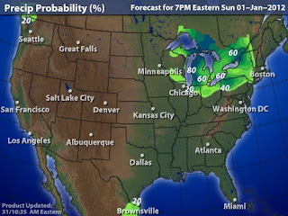
Valid 7:00 pm EST |
In the evening hours, there will still be potential for some precipitation in the Great Lakes area, where strong winds will bring in harshly cold air to start the new year.
SNOW ACCUMULATIONS |
| 48 hour snowfall from intellicast.com |
 |
| 48 hour snowfall from intellicast.com |
There is potential for upwards of 8 inches in Michigan from this lake effect snow, with some 1-4 inches of snow across Minnesota and Wisconsin from the system itself, and some lake effect snow closer to the Lakes. By far, Michigan's both upper and lower sections will be the hardest hit. Accumulations may look light on the Eastern side of the Lakes, but that may be because the lake effect machine is only starting to kick in at the 48 hour mark.
WIND SPEEDS
 |
| WINDcast from intellicast.com |
Winds will be very strong on New Year's day, with sustained winds over 30 MPH on land, and over 45 MPH on Lake Michigan.
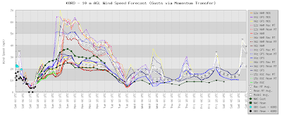
Here's a meteogram based in Chicago IL, one of the harder hit areas we are expecting of the winds. You can use the dashed lines that say (i.e. 06z GFS Max MT) for wind gusts, because 'Max MT' is essentially meaning the maximum wind gust that may happen in the area, in this case Chicago. (Mean MT is the mean wind gust expected.)
 |
| Click to enlarge |
The 6z GFS Max MT is up at 70 MPH! Now keep in mind that the Max MT is the ultimate maximum for wind speeds and probably will not happen. A more reliable wind gust measurement would be the mean MT.
Have a great New Years!


No comments:
Post a Comment