Akshay Deoras
Severe Weather Forecaster
The much anticipated and quasi-stationary cyclone BOB D1 ( Thane) as expected is in the very FINAL STAGE of intensification.
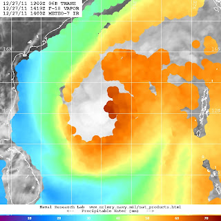
The Microwave imagery coupled with the PW spectrum imagery shows a phenomenal decrease in the available moisture around the system clearly depicting and confirmed by JTWC that Thane has exited its "Intensification Region" where there was ample of moisture to sustain robust convection!
Further the system has entered a region of much cooler SST of the order of 26-27C as against the past HIGH SST.

The above imagery from NRL of the Brightness temp indicates the system's environment is much colder than previous and brighter convection is ongoing in the South Eastern periphery of the LLCC.
A confirmation to the decrease in the moisture environment is depicted below from two images of 27th Dec and 28th Dec respective order. There has been a classic decrease in the PW.
The LLCC also has shrunk today unlike the broad nature of yesterday given the lacking low level convergence. Robust convection continues in the LLCC given the Poleward Outflow of 20kt.
The overall symmetry of TS Thane indicates a peak convection cloud top temp of -70C at the LLCC aloft,two outflow channels have also developed at the North East and South Western periphery of the system…
The banding feature also has weakened around the system!
Forecast ( Valid +12hrs 0600GMT,28th Dec)
The system is expected to WEAKEN henceforth considering the cut off from abundant moisture field,encountering cooler SST and lack of lower convergence. A marginal possibility ( IMD) of further intensification in the next 12hrs which METD WEATHER rules out.
The system is expected to cross the Indian coast near Chennai on 29th Dec 2011 late period!
Akshay Deoraswww.scribd.com/akshaydeoras
Severe Earth & Space Weather Forecaster,Astrophysics article writer.
Web-
www.akshaydeoras.blogspot.com
www.metdweather.blogspot.com


No comments:
Post a Comment